Master Index Nearest Caches Hent avel an heol 6 by Tyanou (1,5/1,5)
N47° 50.980 W4° 18.594 (WGS84) UTM 30T E 402005 N 5300422 Use waypoint: GC1YQWR Size:  Small Hidden on 16-09-2009 Small Hidden on 16-09-2009
In Finistčre Bretagne, France Difficulty:  Terrain: Terrain:
*No attributes specified* Add cache to watch list Log your visit Picture Gallery |
| "Hent avel an heol", "La route du vent solaire" "the road of the
solar wind", un parcours magnifique jusqu'ŕ la pointe du raz...
Bel ensemble chapelle et calvaire sous les cyprés. Beautiful group chapel and Calvary under cyprés. |
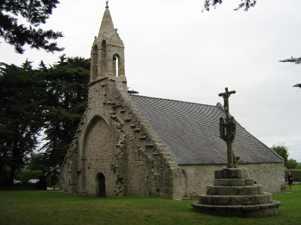
La chapelle de Beuzec cap caval (ancienne grande
paroisse au moyen âge, aujourd'hui sur la commune de Plomeur) date
du XIIčme pour le choeur et la verričre de 1400.
Une fontaine est située ŕ 500 m au nord, un dolmen ŕ 200 m au sud
et une stčle christiannisée ŕ l'est.
La cache est aux coordonnées N 47°50.980 W 004.18.594 Bonne
visite !
The chapel of Beuzec cap caval (former big parish in the Middle
Ages, today on the commune of Plomeur) dates the XIIth for the
choir and the window of 1400.
A fountain is situated in 500 m in the North, a dolmen in 200 m in
the South and a christiannised stele in the East.
The hiding place is coordinates N 47°50.980 W
004.18.594 Good visit!
Bien noter la lettre et le chiffre sur le logbook, une cache bonus
sera déterminée avec ces éléments.
Note the letter and the number on the logbook, a hiding place bonus is determined with these elements.
.
target="_blank"> border="1" />
Consultez le site
target="_blank">Geocaching
en France
Additional Waypoints
DO1YQWR - Dolmen de KerugouN 47° 50.768 W 004° 18.565
FO1YQWR - fontaine de Beuzec
N 47° 51.159 W 004° 18.721
ST1YQWR - Ar groas veur
N 47° 50.995 W 004° 18.363
Additional Waypoints (3)
| Code | Name | Type | Links | Comments | Date | Coordinates | Distance |
| DO1YQWR | Dolmen de Kerugou | Reference Point | Google Maps | 04-10-2009 | N 47° 50.768 W 4° 18.565 | 0,39 kms S | |
| FO1YQWR | fontaine de Beuzec | Reference Point | Google Maps | 04-10-2009 | N 47° 51.159 W 4° 18.721 | 0,37 kms NW | |
| ST1YQWR | Ar groas veur | Reference Point | Google Maps | 04-10-2009 | N 47° 50.995 W 4° 18.363 | 0,29 kms E |
Current at 24-06-2010
![]() 09-06-2010 by 2megalodon
09-06-2010 by 2megalodon
sehr schön, merci beaucoup
![]() 08-06-2010 by rpo7
08-06-2010 by rpo7
Our GC...
![]() 08-06-2010 by rpo7
08-06-2010 by rpo7
16:25
Another nice place. Thanks and greetings from Czech Republic!
![]() 08-06-2010 by Reisender35708
08-06-2010 by Reisender35708
Thank you for hiding.
![]() 20-05-2010 by dersakse
20-05-2010 by dersakse
Trouvé facilement.
Out: TB
Nearby Caches
GC1YNM7 Hent avel an heol 3 (1,51 kms NW)
GC1YP9X Hent avel an heol 4 (2,77 kms N)
GC1YPRW Hent avel an heol 5 (3,32 kms NW)
GC1ZKR5 Hent avel an heol (bonus) (4,38 kms N)
GC27F15 Pesked Ar Gelveneg (6,16 kms S)
Hints (Back)
Hint : «Au bas du muret ŕ droite des grosses
pierres»
Hint: " At the foot of the low wall to the right of big
stones"