Master Index Nearest Caches Torrecilla, Ronda (Málaga) by ^ozo^ (1,5/3,5)
N36° 40.531 W4° 59.774 (WGS84) UTM 30S E 321621 N 4060734 Use waypoint: GCR9RE Size:  Regular Hidden on 11-11-2005 Regular Hidden on 11-11-2005
In Nil, Spain Difficulty:  Terrain: Terrain: 
|
|
| En lo mas alto del Pico Torrecilla, a 1919 metros de altitud. Un paseo de entre 6 y 8 horas ida y vuelta. / On the highest point of the Pico Torrecilla, at an altitude of 1919 meters. A walk of 6 to 8 hours one way and return. |

|
|
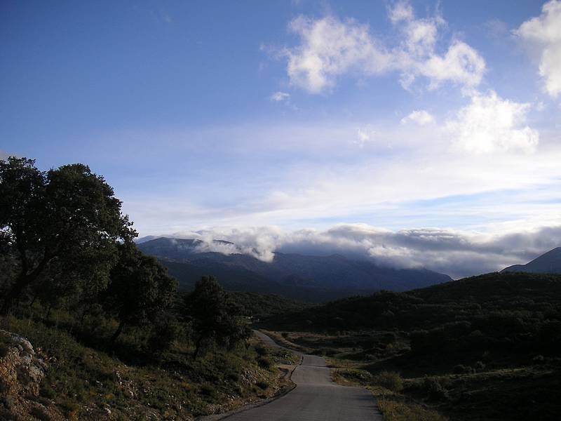
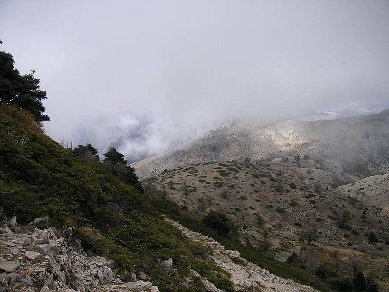
EL PICO TORRECILLA (1919 m.) Nos encontramos ahora en la Sierra de las Nieves o Serranía de Ronda, haciendo uno de los itinerarios más interesantes que se pueden hacer por el Parque. El objetivo es alcanzar la cumbre reina de la Sierra, el Torrecilla (1919 m.). Se recomienda efectuarlo en tiempo de nieve, ya que estas cumbres, como todas, adquieren una especial belleza cuando se cubren de un manto blanco, pero verdaderamente, excepto en época estival, cualquier fecha es buena. También hay que advertir, aunque el fenómeno no es frecuente, que en ańos especialmente crudos las laderas del Torrecilla pueden helarse durante varios días, y su pendiente es suficiente para obligar el uso de crampones. |
|
Advertencia: Cuidado con el recorrido, son unos 24 kms ida y vuelta, fuertes pendientes y zonas de piedras sueltas | |
|
El punto de partida elegido es Los Quejigales. Desde aquí continuaremos unos quinientos metros por el Carril del Sabinal en dirección noreste, observando la primera vaguada que se abre a nuestra derecha y que sube por la ladera de la Sierra de la Nieve. Para alcanzar el principio de la vaguada, habremos de abandonar el carril y cruzar el bosquecillo de pinos con un suelo generalmente muy encharcado, ya que aquí corren varios reguerillos del Arroyo de las Carboneras. Al llegar al pie de la Cańada del Cuerno, que así se llama esta empechada vaguada, buscaremos en la ladera de la derecha el sendero de ascenso. Es importante encontrarlo, ya que de otra manera la subida sería muy fatigosa. El sendero va subiendo marcando amplias curvas para romper la pendiente, y siempre entre el precioso Pinsapar que aquí crecre. Con frecuencia tendremos que saltar sobre enormes troncos de estos abetos abatidos por la edad, o pararnos a contemplar los carámbanos de hielo transparente que se forman entre las rocas calizas que bordean el camino. Al alcanzar los 1600 m de altura, los pinsapos empiezan a ralear, y tras un último repecho llegamos al Puerto de los Pilones. Por el puerto pasa una pista que saliendo de Los Quejigales, lleva hasta un repetidor que se encuentra allí arriba. Tomaremos pues por la pista hasta su final, dejando la casa de piedra del repetidor a la izquierda, y buscando el sendero al Torrecilla por nuestra derecha, en dirección sureste. El sendero es amplio y bien marcado, excepto cuando se cubre de nieve y desaparece por completo. De todas formas, la cima del Torrecilla, por su altura, destaca y es visible desde casi todos lados, por lo que basta dirigir nuestros pasos hacia ella procurando no perder altura. Los pinsapos han desaparecido por completo, y ahora caminamos por un amplio quejigal de ejemplares viejos, los cuales, durante el invierno, por perder sus hojas, adquieren con sus retorcidos troncos figuras atormentadas. Próximos ya al Torrecilla, llegaremos a una nave existente al pie de su ladera noroeste, y allí, bajo una roca, tenemos una fuente de aguas frías. El cerro de la Plazaleta, culminado por el Torrecilla, se nos aparece ahora al alcance de la mano, pero para coronarlo deberemos primero superar los últimos doscientos metros de desnivel, zigzagueando por la ladera hacia el extremo norte de su cordal. Alcanzada ésta, la pendiente se hace más suave y ya sin dificultad alcanzamos la blanca columna del vértice geodésico. Desde la cumbre, la vista es impresionante y ante nuestros ojos se abre un amplio horizonte que alcanza no ya toda la superficie del Parque, sino objetivos mucho más distantes: desde el macizo de Grazalema hasta la blanca dorsal de Sierra Nevada, y en días claros, Gibraltar, el Estrecho y la cadena del Atlas sobre el continente africano. Excepto en la zona del noroeste, el Torrecilla se encuentra rodeado de caídas muy abruptas y el camino de regreso recomendado es el mismo. Sin embargo, en caso de travesías es posible descender por el Puerto de los Valientes, alcanzar el Cerro Corona y desde allí, por ejemplo Tolox. Igualmente podemos desviarnos hacia el norte antes de llegar al Puerto de los Pilones, encaminarnos hacia el Peńón de los Enamorados y enlazar con cualquiera de otros itinerarios hacia Yunquera o El Burgo. También conviene saber que desde el Puerto de los Pilones podemos bajar hasta Los Quejigales por el carril ya descrito. El camino es bastante más largo y monótono, pero también más fácil, y en caso de contratiempo, una alternativa interesante. El tesoro esta escondido bajo una acumulación de piedras, no creo que tenga mucha dificultad en encontrarlo. | |
 |
THE TIP TORRECILLA (1919 ms.) |
| We are now in the Sierra de las Nieves or
Serranía de Ronda, doing one of the most interesting
itineraries than can be done in the Park. The objective is to
reach the summit reigns of the Sierra, Pico Torrecilla (1919
m). It is recommended to carry it out in snowy weather, since these summits, like all, acquire a special beauty when they are covered with a white mantle, but truly, except at summer time, any day is good. Also it is necessary to warn, although the phenomena is not frequent, that in specially crude years the slopes of the Pico can freeze during several days, and its slope is steep enough to need climbing irons. | |
|
Warning: Be careful on the route, roundtrip is about 24 km , steep slopes and zones of loose stones | |
|
The point to begin is Los Quejigales. From there
we will continue about five hundred meters by the Carril del
Sabinal in northeast direction, observing the first low part of the
valley that is opened to our right and that rises by the slope of
the Sierra de la Nieve. | |